12월 19일자 구글 LatLong 블로그 소식입니다. 며칠전 올렸던 구글어스 영상추가지역 퀴즈에 대한 해답, 그리고 영상 추가 또는 갱신된 지역에 대한 리스트입니다.
머... 우리나라 영상추가지역도 저번 포스트에서 말씀드렸으니 더 말씀드릴 게 없네요.
민, 푸른하늘
====
http://google-latlong.blogspot.com/2007/12/where-in-world-is-answers.html
Wednesday, December 19, 2007 at 3:40 PM
모두들 수고 많으셨습니다. 저는 블로거들께서 매번 영상 갱신 지역을 얼마나 빨리 알아내시는지 항상 감명받습니다. 아래는 힌트에 대한 답년과, 이번 영상추가지역 전체 리스트입니다.
1) A young boy living in this town designed the Alaska state flag 32 years prior to Alaska
gaining statehood.
-- 13 year old Benny Benson designed the current Alaska state flag while living in Seward, AK.
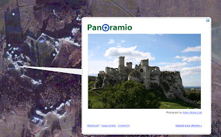
2) The incredible ruins of an old medieval castle, believed damaged during the Swedish
invasion of 1655, are now visible in Google Earth.
-- Ogrodzieniec, Poland
3) On July 3, 1810, this city declared independence from Spain.
-- Santiago de Cali declared independence from Spain 17 days before the national revolt in Bogata. It wasn't until 1819 that Colombia won its freedom.
4) This city's metropolitan area is the most populous in the world, with over 35 million people.
-- Despite a national declining population, the greater Tokyo area has held this title since the 70's.
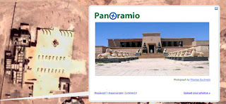
5) This city, known as the City of Peace for hosting many peace conferences, is a popular
tourist destination.
-- Sharm el-Sheikh, Egypt. Check out the amazing Panoramio photos people have taken of this resort hot spot.
6) The oldest Polish cathedral, burial site of many famous Polish leaders, is now high res.
-- The Archcathedral Basilica of St. Peter and St. Paul in Poznan, was first constructed in the second half of the 10th century.
7) This Jersey city is now high res.
-- I said Jersey, not New Jersey. ;) Saint Helier, the capitol of Jersey (a British Crown Dependency located off coast of Normandy) is now high res.
8) Lawrence of Arabia and Cleopatra were both shot at this famous studio.
-- Atlas Studios in Ouarzazate, Morocco.
9) This city is also Ukraine's largest port.
-- Odesa, Ukraine
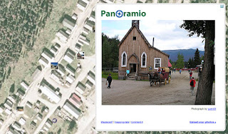
10) Though completely destroyed in an 1868 fire, this gold rush town was completely
restored by the government of British Columbia to act as a tourist attraction.
-- Barkerville, British Columbia
11) This was the final port of call for the Titanic before it's ill-fated transatlantic journey.
-- Cobh, Ireland, where the Titanic picked up most of it's third-class passengers.
12) Bach, 38 at the time, was appointed the cantor for St Thomas' Church in this city
-- Leipzig, Germany
13) This deep-water port was constructed in the middle of a bay and is connected to the
mainland by the third longest bridge in the world.
-- You can view the incredible infrastructure development at the Yangshan deep-water port outside of Shanghai.
14) The element Hafnium is named after this city's Latin name.
-- Hafnium was named after Copenhagen's Latin name: Hafnia.
15) The picturesque port in this city has been painted many times over, and helped inspire
the Impressionist movement.
-- The port of Honfleur, France was painted by the likes of Gustave Gourbet, Claude Monet, and Johan Jongkind.
16) Famous as the site where Portuguese explorer Pedro Álvares Cabral landed in Brazil, this
city is now a tourist destination.
-- Pedro Álvares Cabral, thinking he had landed on an Island, originally named Porto Seguro The Island of the True Cross.
17) The imagery above the headquarters of my favorite search engine has been upgraded!
-- The Googleplex in Mountain View, California!
아래는 이번 영상 추가지역 리스트입니다.
New high resolution:
Americas:
- Canada: Significant amount of British Columbia
- USA: Jefferson City (MO), Central Virginia, Tioga County (NY), Cayuga County (NY),
Jefferson County (NY), Broome County (NY),
- Brazil: Uberlandia
- Colombia: Cali, Pasto
- Mexico: Veracruz
Europe, Middle East and Africa:
- France: Le Havre, Dunkerque
- Poland: Poznan
- Russia: Yaroslavl, Ivanovo, Vladikavkaz, Volzhskiy, Barnaul
- Ukraine: Rivne, Odesa
- Morocco: Agadir
- Nigeria: Abuja
- New Zealand: Manawatu Wanganui Province, Thames-Coromandel Province
- China: Guiyang, Zhaoqing, Zhongshan, Neijang, Anshun, Zhuzhou, Changde,
Jiaoijang, Sashi, Qinhuangdao, Mudanjiang
- Indonesia: Sukabumi, Surakarta
2.5m imagery for the eastern half of Egypt.
Updated Imagery:
Americas:
- Canada: Calgary
- USA: Bend (OR), Reno (NV), Googleplex (CA), San Miguel (CA), Paso
Robles (CA), Buellton (CA), Thousand Oaks (CA), Los Angeles (CA), Orange
County (CA), Denver (CO), Saint Louis (MO), Knoxville (TN), Chattanooga (GA),
Dayton (CA), Atlanta (GA), Desoto County (FL), Onondaga County (NY), Cayuga
County (NY), McAllen (TX), Sanger (CA), Bellevue (WA)
Europe, Middle East and Africa:
- France: Nantes, Lyon
- Germany: Sindelfingen, Ausburg, Leipzig, Aachen
- Denmark: Entire country
- Niger: Niamey
- Zimbabwe: Harare
- South Africa: Johannesburg
- Iran: Tehran
Asia:
- Japan: Tokyo, Osaka, Nagano - Thailand: Bangkok
- Vietnam: Hanoi
Antarctica: new 15m imagery
Updated Terrain:
Massachusetts
머... 우리나라 영상추가지역도 저번 포스트에서 말씀드렸으니 더 말씀드릴 게 없네요.
민, 푸른하늘
====
http://google-latlong.blogspot.com/2007/12/where-in-world-is-answers.html
Wednesday, December 19, 2007 at 3:40 PM
모두들 수고 많으셨습니다. 저는 블로거들께서 매번 영상 갱신 지역을 얼마나 빨리 알아내시는지 항상 감명받습니다. 아래는 힌트에 대한 답년과, 이번 영상추가지역 전체 리스트입니다.
1) A young boy living in this town designed the Alaska state flag 32 years prior to Alaska
gaining statehood.
-- 13 year old Benny Benson designed the current Alaska state flag while living in Seward, AK.
2) The incredible ruins of an old medieval castle, believed damaged during the Swedish
invasion of 1655, are now visible in Google Earth.
-- Ogrodzieniec, Poland

3) On July 3, 1810, this city declared independence from Spain.
-- Santiago de Cali declared independence from Spain 17 days before the national revolt in Bogata. It wasn't until 1819 that Colombia won its freedom.
4) This city's metropolitan area is the most populous in the world, with over 35 million people.
-- Despite a national declining population, the greater Tokyo area has held this title since the 70's.
5) This city, known as the City of Peace for hosting many peace conferences, is a popular
tourist destination.
-- Sharm el-Sheikh, Egypt. Check out the amazing Panoramio photos people have taken of this resort hot spot.
6) The oldest Polish cathedral, burial site of many famous Polish leaders, is now high res.
-- The Archcathedral Basilica of St. Peter and St. Paul in Poznan, was first constructed in the second half of the 10th century.
7) This Jersey city is now high res.
-- I said Jersey, not New Jersey. ;) Saint Helier, the capitol of Jersey (a British Crown Dependency located off coast of Normandy) is now high res.
8) Lawrence of Arabia and Cleopatra were both shot at this famous studio.
-- Atlas Studios in Ouarzazate, Morocco.
9) This city is also Ukraine's largest port.
-- Odesa, Ukraine
10) Though completely destroyed in an 1868 fire, this gold rush town was completely
restored by the government of British Columbia to act as a tourist attraction.
-- Barkerville, British Columbia
11) This was the final port of call for the Titanic before it's ill-fated transatlantic journey.
-- Cobh, Ireland, where the Titanic picked up most of it's third-class passengers.
12) Bach, 38 at the time, was appointed the cantor for St Thomas' Church in this city
-- Leipzig, Germany
13) This deep-water port was constructed in the middle of a bay and is connected to the
mainland by the third longest bridge in the world.
-- You can view the incredible infrastructure development at the Yangshan deep-water port outside of Shanghai.
14) The element Hafnium is named after this city's Latin name.
-- Hafnium was named after Copenhagen's Latin name: Hafnia.
15) The picturesque port in this city has been painted many times over, and helped inspire
the Impressionist movement.
-- The port of Honfleur, France was painted by the likes of Gustave Gourbet, Claude Monet, and Johan Jongkind.
16) Famous as the site where Portuguese explorer Pedro Álvares Cabral landed in Brazil, this
city is now a tourist destination.
-- Pedro Álvares Cabral, thinking he had landed on an Island, originally named Porto Seguro The Island of the True Cross.
17) The imagery above the headquarters of my favorite search engine has been upgraded!
-- The Googleplex in Mountain View, California!
아래는 이번 영상 추가지역 리스트입니다.
New high resolution:
Americas:
- Canada: Significant amount of British Columbia
- USA: Jefferson City (MO), Central Virginia, Tioga County (NY), Cayuga County (NY),
Jefferson County (NY), Broome County (NY),
- Brazil: Uberlandia
- Colombia: Cali, Pasto
- Mexico: Veracruz
Europe, Middle East and Africa:
- France: Le Havre, Dunkerque
- Poland: Poznan
- Russia: Yaroslavl, Ivanovo, Vladikavkaz, Volzhskiy, Barnaul
- Ukraine: Rivne, Odesa
- Morocco: Agadir
- Nigeria: Abuja
- Egypt: 2.5m imagery for eastern half of the country
Asia & Oceania:
- Japan: Kagoshima, HamamatsuAsia & Oceania:
- New Zealand: Manawatu Wanganui Province, Thames-Coromandel Province
- China: Guiyang, Zhaoqing, Zhongshan, Neijang, Anshun, Zhuzhou, Changde,
Jiaoijang, Sashi, Qinhuangdao, Mudanjiang
- Indonesia: Sukabumi, Surakarta
2.5m imagery for the eastern half of Egypt.
Updated Imagery:
Americas:
- Canada: Calgary
- USA: Bend (OR), Reno (NV), Googleplex (CA), San Miguel (CA), Paso
Robles (CA), Buellton (CA), Thousand Oaks (CA), Los Angeles (CA), Orange
County (CA), Denver (CO), Saint Louis (MO), Knoxville (TN), Chattanooga (GA),
Dayton (CA), Atlanta (GA), Desoto County (FL), Onondaga County (NY), Cayuga
County (NY), McAllen (TX), Sanger (CA), Bellevue (WA)
Europe, Middle East and Africa:
- France: Nantes, Lyon
- Germany: Sindelfingen, Ausburg, Leipzig, Aachen
- Denmark: Entire country
- Niger: Niamey
- Zimbabwe: Harare
- South Africa: Johannesburg
- Iran: Tehran
Asia:
- Japan: Tokyo, Osaka, Nagano - Thailand: Bangkok
- Vietnam: Hanoi
Antarctica: new 15m imagery
Updated Terrain:
Massachusetts