2월 19일자 구글 LatLong 블로그 소식입니다. 2008년들어 처음으로 구글어스 영상이 추가 또는 갱신되었다는 소식입니다.
사실 저는 어제 저녁에 Google Earth Blog 와 Digital Earth Blog를 통하여 스페인 등의 지역에서 고해상도 영상이 추가되었다는 소식을 들었기 때문에, 오늘엔 이 뉴스가 나올지 미리 알고 있었더랬습니다.
다음은 지금까지 Google Earth Blog 에 나온 영상추가지역 리스트입니다. (아래 원문엔 예전과 마찬가지로 퀴즈 형식이라서 번역을 생략했습니다.)
확인하는 방법과, 2007년에 업데이트된 지역은 여기와 여기를 확인해 보시기 바랍니다.
민, 푸른하늘
====
http://google-latlong.blogspot.com/2008/02/where-in-world-is.html
Tuesday, February 19, 2008 at 11:35 AM
구글어스를 사랑해주시는 모든 분들께 감사드립니다.
준비에만 꼬박 두달이 걸렸지만, 마침내 2008년 최초로 구글어스 영상을 업데이트하게 되었습니다. 기다리신 보람이 있을 것이라 생각합니다. 이번 업데이트는 주로 미국 부근이지만, 전세계에 걸쳐 고 품질의 영상도 몇몇 군데 추가되었습니다.
1) This city is getting a belated Australia Day present from the Google Earth Team.
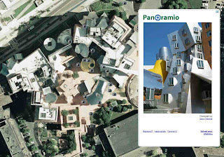
2) Until now, this famous Frank Gehry building was shown as under construction.
 3)
This city is host to a young basketball team that's very exciting to
watch, despite having their top draft pick sidelined for the entire
season.
3)
This city is host to a young basketball team that's very exciting to
watch, despite having their top draft pick sidelined for the entire
season.
4) Still providing spring water, this architectural landmark is one of the best-preserved Roman constructions on the Iberian Peninsula.
 5) This salt dome is not only home to one of my favorite hot sauces but also a bird sanctuary.
6) Named after the 13th century bishop of Toulouse, this historic California mission town can be viewed in high-res.
7) This city has an amazing mix of Islamic and European architecture, including a church built inside a former mosque.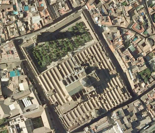 8) You can now view The Manor where the Whiskers, Lazuli, Commandoes, Zappa, and Starsky families live and play.
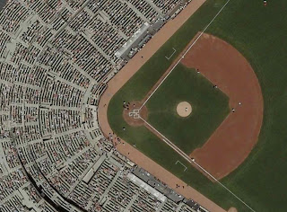
9) Come to this city to join me at a Giants game.
 10)
Every year on January 20th, this city is awash with drum beats while
adults march through the streets dressed as cooks and soldiers.
10)
Every year on January 20th, this city is awash with drum beats while
adults march through the streets dressed as cooks and soldiers.
====
구글 LatLong 블로그 목록 : http://heomin61.tistory.com/6
사실 저는 어제 저녁에 Google Earth Blog 와 Digital Earth Blog를 통하여 스페인 등의 지역에서 고해상도 영상이 추가되었다는 소식을 들었기 때문에, 오늘엔 이 뉴스가 나올지 미리 알고 있었더랬습니다.
다음은 지금까지 Google Earth Blog 에 나온 영상추가지역 리스트입니다. (아래 원문엔 예전과 마찬가지로 퀴즈 형식이라서 번역을 생략했습니다.)
- Spain - Catalonia - including Barcelona; Valladolid, Leon, Burgos, Avila, Segovia, Salamanca, Andalucia, Cataluña, San Sebastian, Bilbao, Pamplona, Vitoria-gasteiz, Córdoba, and Gijon
- England - Kent, Norfolk
- France - Tours
- Brazil - São Paulo
- USA
- Ohio, US - New state-wide coverage
- Connecticut, US - New state-wide coverage
- Portland, Oregon, US
- Deleware, US - Updated imagery
- Nevada, US - Some new areas
- New Jersey, US - Many areas updated
- California, US - Areas east of LA have been updated, San Francisco, San Luis Obispo
- Philadelphia, PA, US - The entire metro area
- Salt Lake City Area, UT, US - City and surrounding area (including ski mountains - now summertime)
- Denver, CO, US
- Virginia, US - Norfolk, Newport News
- Hawaii, US - Mona Kea (observatory now visible), Maui, Kauai
- New York, US - Eastern part of Long Island updated
- Massachusetts, US - Parts of Boston/Cambridge updated
- Canada - Woodstock, Ontario; Vancouver (suburbs, not city)
- Norway - Oslo
- Iceland - Reykjavik
- Russia - Parts of St. Petersburg
- Belgium - Pascal says some images around Brussels have been reprocessed, but otherwise the same imagery. See his post.
- Denmark - Roskilde
- Azores - Terceira (the whole island), São Miguel (the whole island)
- Australia - Sydney and surrounding areas (large area to northeast)
- Romania - Bucharest
- New Zealand - Auckland
- South Africa - Remote areas have new high resolution from Cnes/Spot Image
확인하는 방법과, 2007년에 업데이트된 지역은 여기와 여기를 확인해 보시기 바랍니다.
민, 푸른하늘
====
http://google-latlong.blogspot.com/2008/02/where-in-world-is.html
Tuesday, February 19, 2008 at 11:35 AM
구글어스를 사랑해주시는 모든 분들께 감사드립니다.
준비에만 꼬박 두달이 걸렸지만, 마침내 2008년 최초로 구글어스 영상을 업데이트하게 되었습니다. 기다리신 보람이 있을 것이라 생각합니다. 이번 업데이트는 주로 미국 부근이지만, 전세계에 걸쳐 고 품질의 영상도 몇몇 군데 추가되었습니다.
1) This city is getting a belated Australia Day present from the Google Earth Team.
2) Until now, this famous Frank Gehry building was shown as under construction.

4) Still providing spring water, this architectural landmark is one of the best-preserved Roman constructions on the Iberian Peninsula.

6) Named after the 13th century bishop of Toulouse, this historic California mission town can be viewed in high-res.
7) This city has an amazing mix of Islamic and European architecture, including a church built inside a former mosque.

9) Come to this city to join me at a Giants game.

====
구글 LatLong 블로그 목록 : http://heomin61.tistory.com/6