11월 16일자 구글 LatLong 블로그 소식입니다. 작년 이맘때쯤 아이폰용 구글어스가 출시되어서 한동안 시끌벅적 했었는데, 이번엔 아이폰용 구글어스(Google Earth for iPhone)가 2.0로 업그레이드되었다는 소식입니다.
이번 2.0에서는 내지도(My Maps)를 보는 기능이 추가되었고, 정보를 쉽게 확인할 수 있게되었으며, 한글을 포함하여 31개의 언어를 지원한다는 내용이 있습니다.
먼저 내지도(My Maps)를 지원합니다. 구글맵 내지도(My Maps)는 제가 제일 좋아하는 기능중의 하나인데, 구글맵에서 나만의 지도를 만들면, 이것을 아이폰용 구글어스에서 볼 수 있다는 것입니다.
제가 맨처음 아이팟터치를 입수해서 구글어스를 사용해 봤을 때의 감상은 여기를 읽어보시면 되는데, 오늘은 버전 2.0을 어떻게 사용할 수 있는지를 보여드리겠습니다.
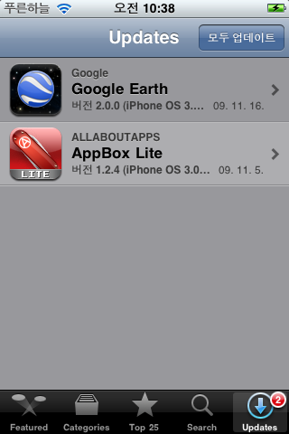
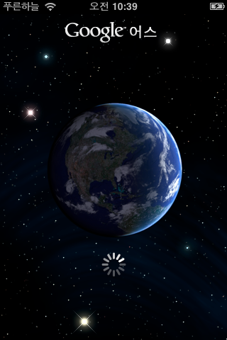
먼저 아래 왼쪽은 아이팟터치 앱스토어에서 업데이트 내역을 확인해 본 것입니다. 버전 2.0.0이 떡하니 등록되어 있습니다. 이걸 누르면 설치를 할 수 있는데... 2.0을 실행하는 모습은 아래 오른쪽 그림과 같이 전혀 달라지지 않았습니다.
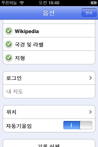
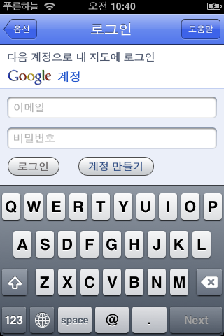
일단 내지도(My Maps)를 사용해 보도록 하겠습니다. 내지도를 사용하려면 당연히 로그인을 해야 합니다. 구글어스 화면에서 오른쪽 아래에 있는 ⓘ (옵션)을 눌러보면 아래와 같이 "로그인"을 보실 수 있습니다. 여기에 구글맵을 사용할 때의 계정을 입력하면 됩니다.
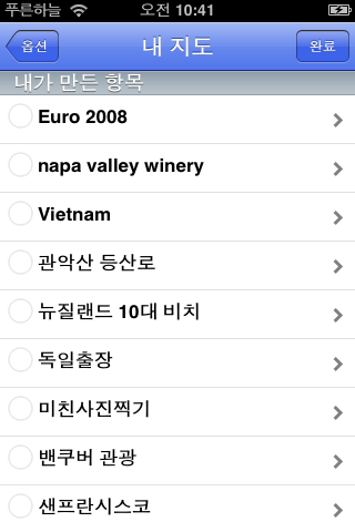
이렇게 계정 설정을 완료하면 구글맵에서 만들어둔 내지도를 볼 수 있게 됩니다. 아래 왼쪽은 제가 만들어둔 내지도 리스트가 뜬 모습이구요, 오른쪽은 지도에 뜬 모습입니다.
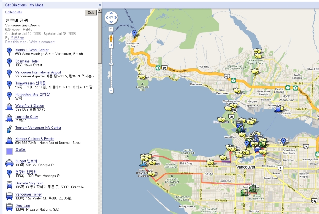
아래는... 확인차 구글맵 내지도에서 동일한 지도를 확인해 본 모습입니다. 동일한 축척은 아니지만, 확인은 가능하실 겁니다.
참고로... 아래 원문에 GPS를 사용하시는 분들이 자신이 지나다닌 경로 등을 아이폰용 구글어스에 띄우는 방법이 설명되어 있습니다.
먼저 데스탑용 구글어스에서 GPX 파일 등을 읽어들이고, 이것을 KML로 저장한 뒤, 구글맵 내지도에서 이 KML을 불러들이고 저장하면 된다는 겁니다. 엄청 복잡하죠. 그래서 저도 테스트 해보지 않았습니다. ^^
====
그런데, 아래 원문에는 한글판 아이폰용 구글어스가 나왔다는 이야기가 분명 있는데, 어떻게도 확인할 방법이 없네요.
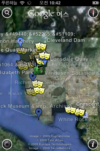
일단 미국계정에서 다운로드 받아둔 현재의 아이폰용 구글어스는 아래 그림처럼 한글이 깨집니다. 왼쪽위에 보이는 선 등이 한글이 깨진 겁니다.
그렇다고... 우리나라 계정으로 앱스토어에 들어가봐도, google earth 항목으로는 검색이 안되고요. 며칠내로 등록이 될지는 모르겠지만, 아무튼 현재는 검색이 안됩니다.
====
아무튼, 제가 제일 좋아하는 기능이 아이폰용 구글어스에 들어와서 무척 기분이 좋습니다만, 아직도 아이폰용 구글어스는 그래도 장난감에 불과합니다. 도로지도가 들어 있지 않기 때문에 제일 필요한 길찾기가 안되기 때문입니다. 그냥 지도를 보는 것만으로는 도움이 되겠습니다만... 이왕이면 도로지도까지 넣을 것이지.... ㅠㅠ
그런데, 사실 구글맵 내지도 기능은 아이폰용 구글맵에 더 필요합니다. 안드로이드용 구글맵외에도 블랙베리, 심비안, 윈도모바일용 구글맵에도 모두 내지도를 불러볼 수 있는 기능이 들어간 걸로 기억하는데, 유독 아이폰에만 내지도 기능이 안들어가고 있습니다. 아마도 애플과 구글이 사사건건 부딪치면서 사이가 나빠졌기 때문이겠죠.
민, 푸른하늘
====
http://google-latlong.blogspot.com/2009/11/update-to-google-earth-for-iphone.html
Monday, November 16, 2009 at 1:10 PM
Just over one year ago, we unveiled Google Earth for the iPhone and iPod touch.
Google Earth quickly became one of the most popular applications in the
App Store, and after only six months, was the second most-downloaded
free application overall. A big thank-you to the over 220,000 users
have taken the time to write a review!
Today, we're proud to announce version 2.0 of Google Earth for iPhone. We've added some exciting new features, including the ability to view maps that you create on your desktop computer right from your iPhone, explore the app in new languages, and improved icon selection and performance.
View your maps wherever you go
Have you ever wanted to view a custom map with Google Earth on your iPhone? Well, now you can. By logging in directly to your Google Maps account, you can view the same maps that you or others have created, using the My Maps interface. Maybe you're on a trip and want to see where Tony Wheeler, the co-founder of Lonely Planet, most likes to travel. Or perhaps you're walking around looking for a restaurant and you want to see where world-famous chef Ferran Adrià likes to eat. All you have to do is click "Save to My Maps", open Earth on the iPhone, log in with the same account information, and voilà, you have your same collection of My Maps right in your pocket.


It's fun to create and view your own maps as well. Here's an example of a map that I created that shows the two attempts my friends and I made to summit Mount Ritter in the Sierra Nevada mountain range. As you can see, we didn't quite make it (the red line is the intended route, and the blue and green lines are our 2008 and 2009 attempts, respectively). Next year we'll get it for sure! I created this map by using the desktop version of Google Earth to read the tracks directly out of my GPS device, saving the resulting tracks as a KML file, and then importing into My Maps in Google Maps. You can learn more about My Maps here.

We hope you enjoy our latest release. Please note that the app will be rolling out around the world over the next twenty-four hours - if you don't see it immediately, be sure to check back soon. You can download Google Earth for iPhone here.
이번 2.0에서는 내지도(My Maps)를 보는 기능이 추가되었고, 정보를 쉽게 확인할 수 있게되었으며, 한글을 포함하여 31개의 언어를 지원한다는 내용이 있습니다.
먼저 내지도(My Maps)를 지원합니다. 구글맵 내지도(My Maps)는 제가 제일 좋아하는 기능중의 하나인데, 구글맵에서 나만의 지도를 만들면, 이것을 아이폰용 구글어스에서 볼 수 있다는 것입니다.
제가 맨처음 아이팟터치를 입수해서 구글어스를 사용해 봤을 때의 감상은 여기를 읽어보시면 되는데, 오늘은 버전 2.0을 어떻게 사용할 수 있는지를 보여드리겠습니다.
먼저 아래 왼쪽은 아이팟터치 앱스토어에서 업데이트 내역을 확인해 본 것입니다. 버전 2.0.0이 떡하니 등록되어 있습니다. 이걸 누르면 설치를 할 수 있는데... 2.0을 실행하는 모습은 아래 오른쪽 그림과 같이 전혀 달라지지 않았습니다.
  |
일단 내지도(My Maps)를 사용해 보도록 하겠습니다. 내지도를 사용하려면 당연히 로그인을 해야 합니다. 구글어스 화면에서 오른쪽 아래에 있는 ⓘ (옵션)을 눌러보면 아래와 같이 "로그인"을 보실 수 있습니다. 여기에 구글맵을 사용할 때의 계정을 입력하면 됩니다.
  |
이렇게 계정 설정을 완료하면 구글맵에서 만들어둔 내지도를 볼 수 있게 됩니다. 아래 왼쪽은 제가 만들어둔 내지도 리스트가 뜬 모습이구요, 오른쪽은 지도에 뜬 모습입니다.
  |
아래는... 확인차 구글맵 내지도에서 동일한 지도를 확인해 본 모습입니다. 동일한 축척은 아니지만, 확인은 가능하실 겁니다.

참고로... 아래 원문에 GPS를 사용하시는 분들이 자신이 지나다닌 경로 등을 아이폰용 구글어스에 띄우는 방법이 설명되어 있습니다.
먼저 데스탑용 구글어스에서 GPX 파일 등을 읽어들이고, 이것을 KML로 저장한 뒤, 구글맵 내지도에서 이 KML을 불러들이고 저장하면 된다는 겁니다. 엄청 복잡하죠. 그래서 저도 테스트 해보지 않았습니다. ^^
====
그런데, 아래 원문에는 한글판 아이폰용 구글어스가 나왔다는 이야기가 분명 있는데, 어떻게도 확인할 방법이 없네요.
일단 미국계정에서 다운로드 받아둔 현재의 아이폰용 구글어스는 아래 그림처럼 한글이 깨집니다. 왼쪽위에 보이는 선 등이 한글이 깨진 겁니다.

그렇다고... 우리나라 계정으로 앱스토어에 들어가봐도, google earth 항목으로는 검색이 안되고요. 며칠내로 등록이 될지는 모르겠지만, 아무튼 현재는 검색이 안됩니다.
====
아무튼, 제가 제일 좋아하는 기능이 아이폰용 구글어스에 들어와서 무척 기분이 좋습니다만, 아직도 아이폰용 구글어스는 그래도 장난감에 불과합니다. 도로지도가 들어 있지 않기 때문에 제일 필요한 길찾기가 안되기 때문입니다. 그냥 지도를 보는 것만으로는 도움이 되겠습니다만... 이왕이면 도로지도까지 넣을 것이지.... ㅠㅠ
그런데, 사실 구글맵 내지도 기능은 아이폰용 구글맵에 더 필요합니다. 안드로이드용 구글맵외에도 블랙베리, 심비안, 윈도모바일용 구글맵에도 모두 내지도를 불러볼 수 있는 기능이 들어간 걸로 기억하는데, 유독 아이폰에만 내지도 기능이 안들어가고 있습니다. 아마도 애플과 구글이 사사건건 부딪치면서 사이가 나빠졌기 때문이겠죠.
민, 푸른하늘
====
http://google-latlong.blogspot.com/2009/11/update-to-google-earth-for-iphone.html
Monday, November 16, 2009 at 1:10 PM
Today, we're proud to announce version 2.0 of Google Earth for iPhone. We've added some exciting new features, including the ability to view maps that you create on your desktop computer right from your iPhone, explore the app in new languages, and improved icon selection and performance.
View your maps wherever you go
Have you ever wanted to view a custom map with Google Earth on your iPhone? Well, now you can. By logging in directly to your Google Maps account, you can view the same maps that you or others have created, using the My Maps interface. Maybe you're on a trip and want to see where Tony Wheeler, the co-founder of Lonely Planet, most likes to travel. Or perhaps you're walking around looking for a restaurant and you want to see where world-famous chef Ferran Adrià likes to eat. All you have to do is click "Save to My Maps", open Earth on the iPhone, log in with the same account information, and voilà, you have your same collection of My Maps right in your pocket.

It's fun to create and view your own maps as well. Here's an example of a map that I created that shows the two attempts my friends and I made to summit Mount Ritter in the Sierra Nevada mountain range. As you can see, we didn't quite make it (the red line is the intended route, and the blue and green lines are our 2008 and 2009 attempts, respectively). Next year we'll get it for sure! I created this map by using the desktop version of Google Earth to read the tracks directly out of my GPS device, saving the resulting tracks as a KML file, and then importing into My Maps in Google Maps. You can learn more about My Maps here.
Browse businesses, photos, and places more easily
Browsing
the world from the palm of your hand can be a thrilling experience, and
viewing photos, Wikipedia articles, and place information is a great
way to discover new parts of the globe. With the latest version of
Google Earth for iPhone, we've made this even easier. Now, when you
touch an icon, a small glow appears under your finger to let you know
which icon you have picked. If your finger touches more than one icon,
you'll be taken to a list of all icons, so you can select the one you
are interested in.

New languages
We've
also included new languages in this release, bringing the total to 31
languages from the original 18. The complete list of languages is:
English (U.S), English (UK), French (France), German, Traditional
Chinese, Simplified Chinese, Dutch, Italian, Spanish, Portuguese
(Brazil), Portuguese (Portugal), Danish, Swedish, Finnish, Norwegian,
Korean, Japanese, Russian, Polish, Turkish, Ukrainian, Arabic, Thai,
Czech, Greek, Hebrew, Indonesian, Malaysian, Romanian, Slovak, and
Croatian.We hope you enjoy our latest release. Please note that the app will be rolling out around the world over the next twenty-four hours - if you don't see it immediately, be sure to check back soon. You can download Google Earth for iPhone here.