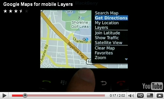
10월 22일자 구글 LatLong 블로그 소식입니다. 블랙베리(BlackBerry) 폰에 모바일 구글맵 버전 3.2를 지원하게 되었다는 내용입니다.
이로써 블랙베리폰에서도 구글맵의 레이어 기능을 지원하게 되었다고 하네요.
즉, 기본적인 지도위에 실시간 교통정보, 위키피디아, 대중교통 등을 지원하게 되었다고 합니다. 아래 원문에 있는 비디오를 보니까 구글 친구찾기인 래티튜드(Latitude)도 지원하네요.

제가 더욱 중요하게 생각하는 건 내지도(My Map) 기능을 지원하게 되었다는 것입니다. 즉, 예를 들어 어디로 여행을 떠나기 전에 여행정보등을 내지도로 만들어 두면, 언제든지 그 정보를 꺼내 볼 수 있다는 것이죠.
그런데... 이 막강한 기능이 아이폰에는 아직 지원되지 않습니다. 원래 안드로이드폰에서는 이 기능이 지원되었고, 지난 7월에는 윈도모바일 과 심비안 S60을 지원하였는데, 이번에 블랙베리까지 합치는 거의 모든 스마트폰을 지원하게 되었지만, 유독 아이폰은 지원하지 않는 것입니다.
제가 지난 7월에 글을 쓸 때, 구글과 애플이 사이가 나빠진 게 아니냐... 라는 글로 마무리를 했었는데, 그 이후 구글의 에릭 슈미츠 사장이 애플의 이사를 사임하고, 인터넷전화 등 구글의 몇가지 응용프로그램을 애플에서 승인을 안해줬다고 해서 분쟁이 발생하는 등, 이제는 거의 돌아올 수 없는 강을 건넌 것 같습니다.
게다가 얼마전 애플에서 도로지도회사를 인수했으니... 아마도 아이폰용 모바일 구글맵 버전 3.2는 아직도 한참 기다려야 하지 않을까... 하는 생각이 듭니다.
민, 푸른하늘
====
http://google-latlong.blogspot.com/2009/10/layers-come-to-google-maps-for.html
Thursday, October 22, 2009 at 1:20 PM
Posted by Michelle Chen, Software Engineer
[Cross-posted from the Google Mobile Blog]
 We're excited to announce that version 3.2 of Google Maps for mobile is now available for BlackBerry. This release contains many of the same features we recently launched on Windows Mobile and S60, including Layers.
Layers make it easy to view various types of information on your map and are especially helpful in situations when you're traveling somewhere new. For example, you can turn on the Wikipedia layer to read entries about nearby places, then use the transit lines layer to help map out a route. Or you can use the My Maps feature of Google Maps to create a collection of places you're planning to visit on your trip and then use Google Maps for mobile to access it from the road. You can also turn on the Google Latitude layer to see your friends' locations.
My coworker Mat is a big fan of Layers and made the below video to show you how he uses the feature. Check out the video, and get the latest version of Google Maps for your phone by visiting m.google.com/maps from your phone's browser.
====
이로써 블랙베리폰에서도 구글맵의 레이어 기능을 지원하게 되었다고 하네요.
즉, 기본적인 지도위에 실시간 교통정보, 위키피디아, 대중교통 등을 지원하게 되었다고 합니다. 아래 원문에 있는 비디오를 보니까 구글 친구찾기인 래티튜드(Latitude)도 지원하네요.

제가 더욱 중요하게 생각하는 건 내지도(My Map) 기능을 지원하게 되었다는 것입니다. 즉, 예를 들어 어디로 여행을 떠나기 전에 여행정보등을 내지도로 만들어 두면, 언제든지 그 정보를 꺼내 볼 수 있다는 것이죠.
그런데... 이 막강한 기능이 아이폰에는 아직 지원되지 않습니다. 원래 안드로이드폰에서는 이 기능이 지원되었고, 지난 7월에는 윈도모바일 과 심비안 S60을 지원하였는데, 이번에 블랙베리까지 합치는 거의 모든 스마트폰을 지원하게 되었지만, 유독 아이폰은 지원하지 않는 것입니다.
제가 지난 7월에 글을 쓸 때, 구글과 애플이 사이가 나빠진 게 아니냐... 라는 글로 마무리를 했었는데, 그 이후 구글의 에릭 슈미츠 사장이 애플의 이사를 사임하고, 인터넷전화 등 구글의 몇가지 응용프로그램을 애플에서 승인을 안해줬다고 해서 분쟁이 발생하는 등, 이제는 거의 돌아올 수 없는 강을 건넌 것 같습니다.
게다가 얼마전 애플에서 도로지도회사를 인수했으니... 아마도 아이폰용 모바일 구글맵 버전 3.2는 아직도 한참 기다려야 하지 않을까... 하는 생각이 듭니다.
민, 푸른하늘
====
http://google-latlong.blogspot.com/2009/10/layers-come-to-google-maps-for.html
Thursday, October 22, 2009 at 1:20 PM
Posted by Michelle Chen, Software Engineer
[Cross-posted from the Google Mobile Blog]
 We're excited to announce that version 3.2 of Google Maps for mobile is now available for BlackBerry. This release contains many of the same features we recently launched on Windows Mobile and S60, including Layers.
Layers make it easy to view various types of information on your map and are especially helpful in situations when you're traveling somewhere new. For example, you can turn on the Wikipedia layer to read entries about nearby places, then use the transit lines layer to help map out a route. Or you can use the My Maps feature of Google Maps to create a collection of places you're planning to visit on your trip and then use Google Maps for mobile to access it from the road. You can also turn on the Google Latitude layer to see your friends' locations.
My coworker Mat is a big fan of Layers and made the below video to show you how he uses the feature. Check out the video, and get the latest version of Google Maps for your phone by visiting m.google.com/maps from your phone's browser.
====