10월 22일자 구글 LatLong 블로그 소식입니다. 계속하여 바이오니어즈 컨퍼런스에 참가한 구글어스 아웃리치팀 이야기입니다.
바이오니어즈 컨퍼런스에서 워크샵을 개최했고, 개인지도를 제작하는 방법, KML을 다루는 방법 그리고 스프레드시트 매퍼를 이용하는 방법 등에 대해 실습이 이루어졌다고 합니다.
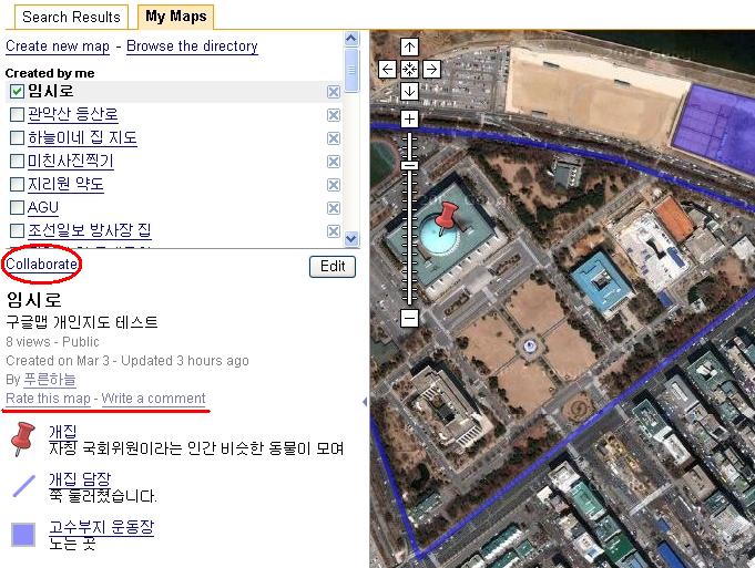
개인지도를 제작하는 방법은 구글맵으로 나만의 지도 만들기라는 글을 참고하시면 됩니다. 아래는 이글에 포함된 그림중 하나입니다.
KML을 사용하는 방법에 대한 글은 구글어스에서 관심장소를 공유하는 방법이라는 글을 읽어보시기 바랍니다. 아주 간단한 내용만 다뤘지만, 그래도 유용하게 사용하실 수 있을 것입니다. KML에 대해 좀더 자세한 내용을 아시고 싶다면 KML 2.1 매뉴얼 (일부)번역본을 읽어보시기 바랍니다.
마지막으로 스프레드시트 매퍼 2.0에 관한 소식... 그러니까 스프레드시트만 정리하면 내가 원하는 지도를 만들 수 있는 방법에 관한 내용은 여기를 읽어보시구요.
민, 푸른하늘
====
http://google-latlong.blogspot.com/2008/10/bioneers-day-three.html
Wednesday, October 22, 2008 at 2:55 PM
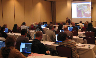
On Monday, the Google Earth Outreach team hosted a workshop for Bioneers participants who wanted to get their hands dirty with the tools they saw at Sunday's Google Earth Outreach plenary and afternoon sessions. We guided about 70 attendees through the processes of creating a custom My Map, building a Google Earth layer, and using the Spreadsheet Mapper tool. In the afternoon, we split the group up into beginners and advanced techies, so we could better train them on the tools and answer their specific questions.
====
구글 LatLong 블로그 목록 : http://heomin61.tistory.com/6
바이오니어즈 컨퍼런스에서 워크샵을 개최했고, 개인지도를 제작하는 방법, KML을 다루는 방법 그리고 스프레드시트 매퍼를 이용하는 방법 등에 대해 실습이 이루어졌다고 합니다.
개인지도를 제작하는 방법은 구글맵으로 나만의 지도 만들기라는 글을 참고하시면 됩니다. 아래는 이글에 포함된 그림중 하나입니다.
KML을 사용하는 방법에 대한 글은 구글어스에서 관심장소를 공유하는 방법이라는 글을 읽어보시기 바랍니다. 아주 간단한 내용만 다뤘지만, 그래도 유용하게 사용하실 수 있을 것입니다. KML에 대해 좀더 자세한 내용을 아시고 싶다면 KML 2.1 매뉴얼 (일부)번역본을 읽어보시기 바랍니다.
마지막으로 스프레드시트 매퍼 2.0에 관한 소식... 그러니까 스프레드시트만 정리하면 내가 원하는 지도를 만들 수 있는 방법에 관한 내용은 여기를 읽어보시구요.
민, 푸른하늘
http://google-latlong.blogspot.com/2008/10/bioneers-day-three.html
Wednesday, October 22, 2008 at 2:55 PM
On Monday, the Google Earth Outreach team hosted a workshop for Bioneers participants who wanted to get their hands dirty with the tools they saw at Sunday's Google Earth Outreach plenary and afternoon sessions. We guided about 70 attendees through the processes of creating a custom My Map, building a Google Earth layer, and using the Spreadsheet Mapper tool. In the afternoon, we split the group up into beginners and advanced techies, so we could better train them on the tools and answer their specific questions.
People came from organizations that work in conservation, social justice, and sustainability, like Planetary Coral Reef Foundation, Marin County Search and Rescue, Woodbine Ecology Center, Center for Sustainable Building Research, Mendocino Land Trust, and Forest Trends.

We also had some fantastic guest presentations. Tim Sinnott, GIS Manager of Greeninfo Network,
presented some of the content that Greeninfo has created for Google
Earth, including a KML layer used to help stop the expansion of a
landfill into Marin County wetlands. Brian Hamlin, an independent
developer, followed his GeoDeveloper Series talk,
and demonstrated how to create dynamic with PostGIS database and
GeoServer. Also joining us was Rosalyn Mahashin from Google Grants,
who introduced the participants to the grants and opportunities
available to non-profit organizations, such as Google Grants and Google for Non-Profits.
====
구글 LatLong 블로그 목록 : http://heomin61.tistory.com/6
2008/10/01 - [LatLong] - 비영리기관을 위한 구글어스 교육과정 오픈
2008/10/20 - [LatLong] - 웹버전 구글어스로 프리젠테이션 만들기
2008/10/20 - [LatLong] - 바이오니어즈 컨퍼런스에서의 구글어스
2008/10/21 - [LatLong] - 바이오니어즈 컨퍼런스 두번째날
2008/10/20 - [LatLong] - 웹버전 구글어스로 프리젠테이션 만들기
2008/10/20 - [LatLong] - 바이오니어즈 컨퍼런스에서의 구글어스
2008/10/21 - [LatLong] - 바이오니어즈 컨퍼런스 두번째날